


Del Norte, Lassen, Modoc, Plumas & Siskiyou Counties PUMA, California
About
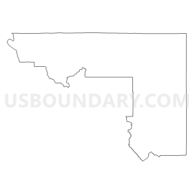
Outline
Summary
| Unique Area Identifier | 192198 |
| Name | Del Norte, Lassen, Modoc, Plumas & Siskiyou Counties PUMA |
| State | California |
| Area (square miles) | 19,114.03 |
| Land Area (square miles) | 18,296.26 |
| Water Area (square miles) | 817.77 |
| % of Land Area | 95.72 |
| % of Water Area | 4.28 |
| Latitude of the Internal Point | 41.40453880 |
| Longtitude of the Internal Point | -121.09061680 |
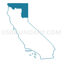
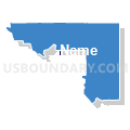
Maps

Graphs
Select a template below for downloading or customizing gragh for Del Norte, Lassen, Modoc, Plumas & Siskiyou Counties PUMA, California


Neighbors
Neighoring Public Use Microdata Area (by Name) Neighboring Public Use Microdata Area on the Map
- Butte County (Northwest)--Chico City PUMA, CA
- Butte County (Southeast)--Oroville City & Paradise Town PUMA, CA
- Colusa, Glenn, Tehama & Trinity Counties PUMA, CA
- Humboldt County PUMA, CA
- Jackson County (Outside Medford & Central Point Cities)--Ashland City PUMA, OR
- Josephine, Coos & Curry Counties PUMA, OR
- Klamath, Malheur, Lake & Harney Counties PUMA, OR
- Nevada & Sierra Counties PUMA, CA
- Shasta County--Redding City PUMA, CA
- Sutter & Yuba Counties--Yuba City PUMA, CA
- Washoe County (North)--Sparks City PUMA, NV
- Washoe County (South) PUMA, NV
Top 10 Neighboring County (by Population) Neighboring County on the Map
- Washoe County, NV (421,407)
- Butte County, CA (220,000)
- Jackson County, OR (203,206)
- Shasta County, CA (177,223)
- Humboldt County, CA (134,623)
- Josephine County, OR (82,713)
- Yuba County, CA (72,155)
- Klamath County, OR (66,380)
- Tehama County, CA (63,463)
- Siskiyou County, CA (44,900)
Top 10 Neighboring County Subdivision (by Population) Neighboring County Subdivision on the Map
- North Valleys CCD, Washoe County, NV (51,813)
- Paradise CCD, Butte County, CA (46,200)
- Susanville CCD, Lassen County, CA (26,758)
- Crescent City CCD, Del Norte County, CA (23,582)
- North Coastal CCD, Humboldt County, CA (22,194)
- Central Shasta CCD, Shasta County, CA (11,527)
- Yreka CCD, Siskiyou County, CA (11,523)
- Southwest Jackson CCD, Jackson County, OR (11,176)
- Cave Junction CCD, Josephine County, OR (7,994)
- East Shasta CCD, Shasta County, CA (7,475)
Top 10 Neighboring Place (by Population) Neighboring Place on the Map
- Susanville city, CA (17,947)
- Cold Springs CDP, NV (8,544)
- Yreka city, CA (7,765)
- Crescent City city, CA (7,643)
- Mount Shasta city, CA (3,394)
- Weed city, CA (2,967)
- Alturas city, CA (2,827)
- East Quincy CDP, CA (2,489)
- Bertsch-Oceanview CDP, CA (2,436)
- Chester CDP, CA (2,144)
Top 10 Neighboring Elementary School District (by Population) Neighboring Elementary School District on the Map
- Susanville Elementary School District, CA (11,632)
- Shaffer Union Elementary School District, CA (10,433)
- Yreka Union Elementary School District, CA (9,939)
- Mount Shasta Union Elementary School District, CA (7,237)
- Black Butte Union Elementary School District, CA (4,366)
- Weed Union Elementary School District, CA (4,044)
- Janesville Union Elementary School District, CA (3,565)
- Golden Feather Union Elementary School District, CA (2,673)
- Dunsmuir Elementary School District, CA (2,141)
- Montague Elementary School District, CA (2,002)
Top 10 Neighboring Secondary School District (by Population) Neighboring Secondary School District on the Map
- Shasta Union High School District, CA (101,215)
- Oroville Union High School District, CA (53,032)
- Northern Humboldt Union High School District, CA (44,379)
- Red Bluff Joint Union High School District, CA (42,667)
- Lassen Union High School District, CA (28,166)
- Yreka Union High School District, CA (17,784)
- Siskiyou Union High School District, CA (16,201)
- Dunsmuir Joint Union High School District, CA (2,499)
- Trinity Alps Unified School District in Burnt Ranch, CA (803)
- Trinity Alps Unified School District in Junction City, CA (750)
Top 10 Neighboring Unified School District (by Population) Neighboring Unified School District on the Map
- Washoe County School District, NV (421,407)
- Medford School District 549, OR (84,505)
- Marysville Joint Unified School District, CA (60,976)
- Three Rivers School District, OR (47,713)
- Klamath County School District, OR (42,784)
- Paradise Unified School District, CA (39,364)
- Gateway Unified School District, CA (29,487)
- Del Norte County Unified School District, CA (28,610)
- Ashland School District 5, OR (24,282)
- Phoenix-Talent School District 4, OR (24,064)
Top 10 Neighboring State Legislative District Lower Chamber (by Population) Neighboring State Legislative District Lower Chamber on the Map
- Assembly District 2, CA (469,582)
- Assembly District 3, CA (459,287)
- Assembly District 1, CA (443,842)
- Assembly District 32, NV (80,177)
- Assembly District 26, NV (69,333)
- State House District 55, OR (66,629)
- State House District 3, OR (63,226)
- State House District 5, OR (61,343)
- State House District 56, OR (59,231)
- State House District 1, OR (58,501)
Top 10 Neighboring State Legislative District Upper Chamber (by Population) Neighboring State Legislative District Upper Chamber on the Map
- State Senate District 1, CA (1,002,597)
- State Senate District 4, CA (988,287)
- State Senate District 2, CA (897,433)
- Washoe County Senatorial District 2, NV (136,694)
- State Senate District 2, OR (126,966)
- State Senate District 28, OR (125,860)
- State Senate District 3, OR (124,839)
- State Senate District 1, OR (120,277)
- Washoe County Senatorial District 3, NV (115,167)
Top 10 Neighboring 111th Congressional District (by Population) Neighboring 111th Congressional District on the Map
- Congressional District 2, NV (836,562)
- Congressional District 4, CA (774,261)
- Congressional District 2, OR (769,987)
- Congressional District 4, OR (739,234)
- Congressional District 2, CA (708,596)
- Congressional District 1, CA (704,012)
Top 10 Neighboring Census Tract (by Population) Neighboring Census Tract on the Map
- Census Tract 404, Lassen County, CA (9,422)
- Census Tract 3616, Josephine County, OR (8,348)
- Census Tract 9, Siskiyou County, CA (7,231)
- Census Tract 2.01, Del Norte County, CA (7,026)
- Census Tract 10, Siskiyou County, CA (6,991)
- Census Tract 1.05, Del Norte County, CA (6,967)
- Census Tract 1, Plumas County, CA (5,500)
- Census Tract 16, Butte County, CA (5,266)
- Census Tract 126.01, Shasta County, CA (5,195)
- Census Tract 26.13, Washoe County, NV (5,173)
Top 10 Neighboring 5-Digit ZIP Code Tabulation Area (by Population) Neighboring 5-Digit ZIP Code Tabulation Area on the Map
- 97603, OR (29,525)
- 95531, CA (24,528)
- 97520, OR (24,469)
- 96130, CA (23,150)
- 95965, CA (20,384)
- 97415, OR (14,051)
- 89508, NV (11,662)
- 96097, CA (10,031)
- 96067, CA (7,165)
- 97530, OR (6,916)